On one of the most interesting radio days of our recent camping trip, Project TouCans made QSOs with Australia, Japan, Columbia, and Argentina, all on the same day! The QSOs to Japan and Australia were made in the middle of their night. The Japan, Australia, and Columbia QSOs were all made in a sixteen minute window beginning with VK3YV at 12:40 UTC.
What was the Propagation Mode?
While the QSOs were awesome! How did they happen? I did a bit of research.
Spoiler: I don't have an answer yet.
If you have ideas, I'd love help on this, please comment!
Dayside stations talking to nightside stations led me to sv1uy's page on chordal hop propagation which had a nice diagram
The rest of the notes from below followed from this diagram. I don't have answers yet, but here are my notes. I've been talking with the kids about radio occultation, refraction, and of course, the Gladych research project during all of this. I'm also using it to introduce trig which will layer in with the work the 11 and 9 year-olds, (Mota and Tawnse), are doing with fractions.
This mode, (numbered page 4 of Gold's thesis), is interesting because we had plenty of scattering. Notice the mountain peaks and ridges all round us below.
Chordal Modes Introduced with Villard
And we have our first reference to Villard, which included Okinawa, and therefore two different Gladychs, Michael's Project Smoke Puff article, and Stanislaw who was the architect for the Okinwa base in 1955.
And there's a bit of a Gladych aside here that's just too difficult to ignore. Apparently Stanislaw also few planes in World War II? I knew Michael did, but this is the first mention [pdf] I've seen of Stanislaw being a pilot
Carter Manny Jr. worked with Stanislaw. Here's his Chicago Tribune obituary.
Finding Our Antipodal Point
To find the anitpoidal point, we can follow our longitude over the North (or South for that matter) where it will become the same longitude minus 180 degrees, or pi radians if that's the unit you prefer. You can see this in the diagram below where our longitude of about -107 degrees traced over the pole becomes about 73 degrees.
Meanwhile, our latitude above the equator will be used to find the same number of degrees below the equator:
I don't know what propagation mode we had yet. We're going to pull some ionosonde data next to see if there was in fact a 'tilt' in the ionosphere at the time of the QSOs.
A few weeks ago, the 13, 11, and 9 year-old gang and I were out on our yearly camping trip, hanging out near Great Basin National Park above Baker, NV, when KO6BTY and I got to participate in a Ham Radio Workbench episode! It was a lot of fun! (It was also one of the latest nights up we had during the trip.)
If you're landing here from there, we talked about a lot of things including:
We just made it back from our camping trip yesterday, so I hope to have a lot of updates over the next few days, and maybe some pretty pictures as well like this one of Mt. Wheeler and, of course, Project TouCans.
The gang and I made our first QSO with Australia this week!
The QSO came bundled with two other DX contacts made with Project TouCans—all in a 16 minute window—which I'll write about soon. Our camping site is nestled below Anvil Mountain to the East and across the Million Dollar Highway from South Mineral Springs, about two miles north of Silverton, CO. We're surrounded by peaks on all sides. Bear Mountain peak is framed in my pictures of the rig.
Project TouCans was probably 20 feet up in its dipole. This turned out to be difficult to show in photographs with the proper perspective. I finally decided to make a gif of different zoom levels of a single photo. The picture below starts out focused on Bear Mountain Peak and then zooms out to include the rig and the ground outside my partner's and my tent.
You can see the Bluetooth transmitter that brings the head phone audio down to the ground hanging from the bottom of the rig.
The campsite is gorgeous and almost completely bug free. I managed to make it out on one hike. Tawnse—the nine year-old—our puppy, and I were treated to views like this
Notice the mountains lurking very nearby in every shot.
That brings us to the circumstances of the QSO with VK3YV, the first DX QSO of that morning. Here's our campsite from a way's out showing the F2 skip path (estimated using real-time data from the Boulder, CO ionosonde), as well as the path of the QSO along the ground.
Zooming in a bit reveals just how many peaks we were surrounded by and shows our location relative to Silverton.
So, with all those mountains in the way, how did we talk to Australia?
Project TouCans threaded the valley to the west of our campsite! Check this out!
I'll leave you with the map of the QSO so you can trace along the path at your leisure. Use the time control in the lower left corner or the slider along the bottom of the map to locate the QSO at 12:40 UTC. From there, you can zoom in and out using a mouse center-button wheel. You can also tilt by holding down the control key, and then moving the map using the left mouse button.
Update
Due to a bug in the ionosonde code that I'd immediately introduced, the F2 layer height was not 307 km as shown in the diagram above. It was in fact, 235 km over Hawaii which had data at the time, (Boulder, CO in fact did not), and which was closer to the middle of the QSO path as well. The difference in F2 height resulted in the first mountain intersection that used to look like this
with the incorrect data looking like this with the new F2 height data
References
Ionosonde Data
This was made possible with data collected by
Reinisch, B. W., and I. A. Galkin, Global ionospheric radio observatory (GIRO), Earth, Planets, and Space, 63, 377-381, doi:10.5047/eps.2011.03.001, 2011.
POTA activation from Silverton in twenty-one minutes!
Project TouCans had one of its highest ever antenna placements.
It showed in the QSO data. Check out the number of 599 reports, (white qso paths.)
(All QSOs are shown with their associated F2 skip paths.)
I'm loving the, (very real), yet very sci-fi look of what's going on with the F2 skips from this rig at this location
Most of the F2 paths actually cleared the mountain, so I didn't have to think about diffraction or other radio optics effects. VE3EID did plow just a little bit into the mountainside
It did come out the other side. (By the way, you can look at all of this on your own in the map below.)
But, if Ontario plowed into a peak a little bit, how did Puerto Rico KP3CW spot the rig?
Turns out, it's line of sight between mountains from here
QSO Map
Here's the map you can steer around in on your own! Remember, click play in the lower left hand corner, then move the time slider all the way to the left. You'll be able to see all the QSO paths and their F2 skip paths (based on Boulder, CO ionosonde data at the time of the QSO.) If you click play again, you'll be able to see how the QSOs played out over time.
Notes
Difference in Altitude
I'm still working through getting the F2 traces to routinely emit from the ground. This time, Google Maps said the elevation here was 2982.468 m, but Cesium is happier with 2947.468 m, co about 35 meters lower than expected. Even then, we're not on the ground
SQL Query
select
tx_lng,
tx_lat,
rx_lng,
rx_lat,
rm_rnb_history_pres.timestamp,
rm_rnb_history_pres.dB,
rm_rnb_history_pres.Spotter,
haversine(tx_lat, tx_lng, rx_lat, rx_lng) as total_path,
gis_partial_path_lat(tx_lat, tx_lng, rx_lat, rx_lng, 200) as el_lat,
gis_partial_path_lng(tx_lat, tx_lng, rx_lat, rx_lng, 200) as el_lng,
id,
strftime('%Y%m%d', timestamp) as date,
strftime('%H%M', timestamp) as time,
'US-4399' as park,
'KD0FNR' as call,
'BC840' as ionosonde,
2947.468 as elev_tx
from
rm_rnb_history_pres
where
dB > 100
and timestamp > '2024-05-29'
and timestamp < '2024-05-30'
order by
rm_rnb_history_pres.timestamp desc
SQL Query for RBN and QSOs
Due to a bug/oversight in the system, I have to run with tx location coordinates set in the query when I want to include RBN spots, so here's that query
select
-107.7179358 as tx_lng,
37.8227611 as tx_lat,
rx_lng,
rx_lat,
rm_rnb_history_pres.timestamp,
rm_rnb_history_pres.dB,
rm_rnb_history_pres.Spotter,
haversine(tx_lat, tx_lng, rx_lat, rx_lng) as total_path,
gis_partial_path_lat(tx_lat, tx_lng, rx_lat, rx_lng, 200) as el_lat,
gis_partial_path_lng(tx_lat, tx_lng, rx_lat, rx_lng, 200) as el_lng,
id,
strftime('%Y%m%d', timestamp) as date,
strftime('%H%M', timestamp) as time,
'US-4408' as park,
'KD0FNR' as call,
'BC840' as ionosonde,
2947.468 as elev_tx
from
rm_rnb_history_pres
where
timestamp > '2024-05-29'
and timestamp < '2024-05-30'
order by
rm_rnb_history_pres.timestamp desc
References
Ionosonde Data
This was made possible with data collected by
Reinisch, B. W., and I. A. Galkin, Global ionospheric radio observatory (GIRO), Earth, Planets, and Space, 63, 377-381, doi:10.5047/eps.2011.03.001, 2011.
We got to camp a bit more in the middle of nowhere than we usually do while traveling across Utah last weekend. My partner found the Burr Trail Scenic Byway. I've looked for a route across southern Utah for the last several years, but had somehow missed this really nice, well-paved, little road.
We camped at the foot of an East-facing cliff, and the QSO map for the POTA reflected that fact pretty nicely:
Based on this overall map, I didn't think we could hit the West Coast because of this cliff face.
Almost all of the QSOs and spots paid attention to that cliff face. And then, there was N0OI:
How? How had the signal cleared the cliff and skipped out to Perris, CA?
Using data from the Boulder, CO ionosonde, at the time Project TouCans was spotted in California, the F2 layer skip is modeled in the gif below. Note that it clears the mesa, (just barely.)
The other skip off to the Southeast was headed to the Cayman Islands. All of the skewing around is to convince myself that the the F2 path lines up with the path to the spotting station. You'll notice that there's a slight elevation offset that needs to be fixed.
More Notes on the POTA
I blew out my knee a bit sitting on the ground outside the tent for a three hour podcast interview on Friday night, consequently, the gang did most of the station set up including deploying Project TouCans in its dipole. Throughout that process, the family pup kept me company
When the gang were done, we had what, for Project TouCans, was a fairly typical antenna height of about five feet over the ground
One really interesting aspect of this POTA was that I didn't have the ability to Internet spot myself. Frankly, I wasn't sure it was going to work out at all, and for the longest time from about 00:02 GMT 24-05-27 till 13:50 GMT on the same day, it didn't. (Yes, I was asleep for most of that time with the rig turned off.) And then! Thanks—I think—to a few neighboring POTA stations, ops started to realize that TouCans was there! It may have also helped that my first QSO with WI5D was a bit of a rag chew.
Also, while hanging out on the cliff, the gang found an interesting mineral/quartz/mica/I don't know sample of rock. It was flat, broke easily, and contained pockets of crystals that were translucent. Any ideas what this might be?
For the moment, I'll leave you with this map of all the spots and QSOs for the POTA over the course of the evening, and into the next morning. Click play, then move the time slider all the way back to the left to see all the spots and QSOs with their associated F2 skips at once. Then, you can hit play to see how it all unfolded. (Keep in mind, the overnight nothingness is included in the map. You may want to skip over that.)
As a final note, while I'm waiting for all the F2 data to come back, I've been trying to convince the gang that the F2-height datastream from the Boulder, CO ionosonde
is in fact entered manually by a room of accountants not unlike those in John Wick, but to no avail. I guess they're just digital natives :)
Ah! And credits to where the ionosonde data actually is coming from
This was made possible with data collected by
Reinisch, B. W., and I. A. Galkin, Global ionospheric radio observatory (GIRO), Earth, Planets, and Space, 63, 377-381, doi:10.5047/eps.2011.03.001, 2011.
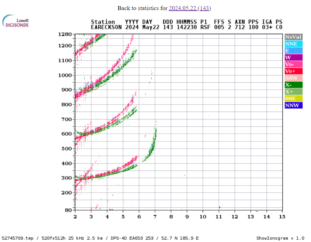
The recent pair of QSOs to Japan from Project TouCans from Great Basin National Park has me wondering about F2 layer ionospheric skip propagation again.
I got our F2 skips working for CZML. Here's a look at the skip path for JJ2JQF de KO6BTY. Notice the Earedson ionosonde is almost right in the middle
to pull in ionosonde data. To access different stations, you need different ursiCode values, (one per station.) These can be found at https://www.digisonde.com/ under the URSI column.
This URL worked great in the browser, but thanks to this issue, stumbled a few times in the czml plugin's calls to get_f2m.
References
Ionosonde Data
This was made possible with data collected by
Reinisch, B. W., and I. A. Galkin, Global ionospheric radio observatory (GIRO), Earth, Planets, and Space, 63, 377-381, doi:10.5047/eps.2011.03.001, 2011.
Today KO6BTY made a QSO to Japan from Great Basin National Park!!!
Not only that, but she also made her first POTA activation! She was operating from Project TouCans as KD0FNR/KO6BTY on 20 meters. Here's the QSO map, (after hitting play in the lower left corner, all the QSOs will shown for a brief moment; if you click pause you can zoom in/out and view all of them at once; continuing with 'play' will remove all QSOs and display each QSO as it happened in time during the activation):
This morning at the 2nd POTA activation here, I got to talk (OK, CW), with JG0AWE again!
Just like last year!
I was using a bit more power this year. Project TouCans is running somewhere between 3 and 5 Watts at the moment.
He caught me just before the gang go the oatmeal ready, (we're camping on the edge of Great Basin National Park), On top of that, a RBN station in Japan had spotted Project TouCans about half an hour before. There wasn't a grey line between our locations, so I'm curious about what was going on, but delighted to have made the QSO!
Here's the activation in Cesium so you can see where the sun was in relation to the QSO. The QSO takes place at 14:49 near the end of the animation.
Tuesday morning, with Project TouCans working better that it had in days, I noticed that the ends of our stranded wire antenna had begun to fray out. I grabbed a roll of washi tape from my pocket, (who doesn't take washi tape on a radio outing?), and a few minutes later, voila
The end of our antenna was no longer frayed, and nosie was down significantly! Here's a view of our activation site from the opposite angle looking out over the Great Basin of Great Basin National Park US-0032.
I made two QSOs last night from the home QTH with a lot of noise! They were to KA6JLT in Reno, NV and and WN1Z in Susanville, CA from here in San Francisco.
This time, we did not measure the power out of Project TouCans. I suspect our several decades old Radio Shack power meter has given up the ghost, or there's something wonky in one of the cheapo connectors from Amazon.
As a side note, the radio is much quieter and works better when the RF output leads are soldered directly to the banana binding posts at the top of the rig that the antenna attaches to.
Side, side note. KO6BTY and I need to keep a slightly cleaner workbench. The rig sparked and vaporized a stray shred of wire yesterday once when we powered it up.
Project TouCans WorkbenchProject TouCans Flies Again
Reading up on the Tuna Topper and funding for amateur radio projects
Since we're now blowing FETs on Project TouCans, and KO6BTY and I are giving a presentation about the rig to the San Francisco Amateur Radio Club on Friday, I've been reading up on amplifier theory. I really like this article explaining how the different classes of amplifiers work except for the horribly gendered first paragraph.
In other reading news, (it's finals week for KO6BTY and I'm getting ready for our camping trip, so mostly all I've had time to do over the last few days is read), Simon Willison pointed out that the Amateur Radio Digital Communications group has grants for advancing the usage and technology of amateur radio. Here are some examples of what's been funded.
And finally, here's a link to the article that taught me how to increase power output on the Tuna Topper by upping the bias voltage. It's an even more cool article now that I know how the calls A Tuna Topper amplifier actually works.
To wrap things up, we're hoping to get TouCans back up and running today. Here's a nighttime look at the rig from the ground. The white object is the 10 meter rig's balun.
Up until about a week and a half ago, Project TouCans and the Flying Rockmite before it had never blown a final amplifier transistor. Our good fortune with transistors was caused in large part not by any particular genius in the construction or handling of the radio, but almost entirely to radio frequency interference. When too much RF energy was reflected back into the radio on key down, the Rockmite's picokeyer would reset chirping out an only slightly irritated 73 in Morse code. Hence, we couldn't use the rig, hence we changed the antenna or repaired the rig, or turned down the bias voltage on the Tuna Topper final until we could use the rig without resetting that little keyer.
Then! Then we did something that was both cool and, (we'd later find out), somewhat daunting. We removed the last of the wires that attached Project TouCans to the Earth and our RFI just went away. Which has been great for signal quality, and as it tuns out it's occasionally been hell on the amplifier.
At present count, we're three transistors down.
After the rig dropped from about 15 feet up to the ground recently, I did a quick inspection and then, (why!!!!??? why did I do that???), decided I'd measure the rig's output power since I hadn't done that in a while. The power meter reported 3 Watts. The rig nominally outputs 5 Watts. I adjusted the bias voltage on the Tuna Topper and.. still 3 Watts. I increased the voltage two more times, and? The final transistor blew out. (Eventually taking the rechargeable battery with it.) KO6BTY and I completed our debug yesterday, reattached the power meter, (which apparently no longer works since it reported 0 Watts at all bias voltages), and fairly quickly blew out the amp transistor again as I blithely upped the bias voltage.
Turns out I can't do that anymore. our keyer RFI safeguard is gone.
Interestingly, we did discover that when the bias is set to low on the amp, there's a whistling feedback tone that appears in the audio output. When the amp is biased correctly, and before it's biased too high and takes out the transistor, (i.e. in nominal operating mode), the whistling tone goes away. Audio debug lives on to a certain extent.
We'll be dropping in transistor number four tomorrow. I'll keep you posted.
It received a certificate of commendation in the GQRP building contest, as well as fourth place in the QRP division at the California QRP party!
Both of these things surprised me a bit. I've been inundated since junior high school with the 'QRP can't do much' schtick, and well? It just ain't true!
TouCans is strung up on a dipole stretching from our roof to a wood pole mounted on our back fence. (Mota, the 11 year-old, and I levered a construction clamp over the lip of the roof using a broom handle from the kitchen window. I did all the window leaning... It was an adventure.) I didn't even realize the QSO party was the weekend it was, and yet that little pineapple can based rig came in pretty close to third!
KO6BTY and I were also tickled pink to receive Certificates of Commendation in the GQRP construction competition! We've done a lot of work on the rig bringing it to it's completely wireless state a few months ago. We've learned about RFI and digital supply noise and Bluetooth audio transmitters as well as Raspberry Pi Pico-Ws and microPython. The whole endeavor actually inspired a microPython class at our local maker space for homeschooling kids (and anyone else who's interested at our local maker space taught by yours truly. Who'd have thought you could have so much fun with a pineapple can? OK, OK, yeah, it was me. I was the one that thought it. :)
Eeeeeep! It's been, well, 11 days in since my last week notes. Sigh....
Here's what's been going on. I spent the first half of that ime working on getting the time stamps back into the ham radio qso kml maps, and I did it!
While working on this, I discovered that I didn't quite know how to include jinja templates inside other jinja templates. I figured it out though.
Meanwhile, I've been methodically trying things as far as adding elevation plots to the kml maps. Things are moving along slowly... and!!! ChatGPT may have just told me how to do the whole thing??? Anyway...
There's a running joke on HamRadioWorkbench about operating mobile from a riding mower. I'm proud to announce that through the wonder that is Project TouCans, WiFi, and Bluetooth, the team here at antigravkids is releasing their first QRP mower w/ ham radio prototype. Both the mower and the 20 meter rig are QRP :) Go ahead, take a listen.
The prototype is enabled by the following technologies:
Project TouCansPico-W Enabled Keying Bluetooth Audio ala JBL Clip 3
Week notes are kinda cool. It's fun to see what happened the week before ,what was planned ahead, and then reflect on that. This week, sigh... Oh, the irony. Reviewing last weeks notes, I found an off-handed comment I made about working on improving audio performance by bringing all the audio wiring inside the rig. This, Did Not. Help. I did get to learn a lot about where the noise in the audio circuits is coming from, I did also invent a new patch that helped out with the Pico-W noise I was originally trying to eliminate. Reflection is pretty useful, actually :)
It's not easy to see the charging light indicator on the Imuto supply when it's properly housed in its Progresso soup can... ahhh... battery pack enclosure! I worked out an audio process for ensuring the charging cables are indeed charging so I don't wake up with a non-functional radio.
I spent a lot of time looking at and reading about the QMX! (I read about it at their site, on qrper.com, and on w6csn.blog.) The heart of this rig will definitely fit into a TouCans case. The next TouCans might be a QMX!
I'm working on ramping up on new writing projects, you know, other than this one.
I've been playing around with mapping the sides of hills for Project TouCans POTA activations. I've getting some interesting results and getting towards automating the process to get to those results.
Goals for the next week
The first goal is to make better goal choices than I did last week. Improve TouCan's audio by putting the wires in the can... Geesh...
OK, here we go:
release datasette-gis-partial-path as a Python package
write a plugin to pull elevation data form Google Maps Elevation API
Figure out a path to get time stamps back into the animated QSO KML maps since the deprecated for over a decade Google Charts API appears to have finally given out.
Maybe get back to writing things like this. Somebody found it this week, and I kinda love it.
As with most of my project, I'm probably having way too much fun with this elevation path thing! I got a new look at our usual Pantoll campground site this morning, and it's really, really cool!
First though, let me point you towards the code that enables my recent fascination with our the layout of the terrain at our POTA activations. I've worked the datasette plugin that returns the coordinate's of a portion of the path between two points code through it's first very simple test case. I do not know if it will install correctly in any installation of Datasette yet, but it install's in mine, and it plays well with the instance in the test case, so here's the repository.
Note for new readers:
Datasette is a Python tool from Simon Willison, described as:
The gang and I have been slowly but surely working at applying Datasette to mapping our ham radio QSOs over the last several months, and in the process have been learning about ionosonde data sources, how to release Python packages, vector math, including cross products, (seriously, check that post out, it includes CoCalc plugins that let you see the cross product process we used to calculate the distance between a point and a path on the Earth. I think it's really cool), and GIS in the form of geocoding via Google Maps, We've use all that information to map the paths between QSOs along the ground as well as the paths of signals skipping between the ground and the F2 layer of the ionosphere. The maps have helped us better visualize high frequency radio propagation.
OK, so now onto more elevation paths!
On our most recent trip to Mt. Tamalpais the gang and I, using TouCans on 20 meters, made POTA QSOs to both Alaska and New Hampshire among other places. I estimated—using a topo map—that the hill rolled down from our campsite at an 18 degree angle. Taking a look at the New Hampshire QSO with WK1V today, I was able to more accurately measure the elevation angle at 22 degrees. Here's the elevation profile of the starting from the campsite at the left hand edge, and extending down the mountain. My vague memories of RF engineering from grad school tell me that only the elevation over the first few wavelengths matter, but it's a lot of fun to look at the a longer path:
So, that's cool, but what about that Alaska, QSO? Does the elevation angle of our campsite point downwards towards Alaska as well? It's possible. Our campsite is at the top of a ridge. Let's look.
As it turns out, to get to Alaska from our campsite, you walk along the ridge and over Mt. Tamalpais!
What's that mean for my favorite radio journal assertion that the angle of the hill subtracts from the elevation angle? Well, for the first three wavelengths along the path, the ridge only rises 20 feet or so. Comparing that 20 foot rise over 60 meters to the 20 meter wavelength of the transmitted waves, that's basically flat, so while the upward slope may not have helped, it also just wasn't very noticeable to the signal at all. At least that's my contention at the moment.
I spent a lot of time this week working on getting radio frequency interference from the rig itself and the Pico-W that controls Project TouCans out of the audio output. Some of this work was not fruitful. Turns out the audio wiring does not belong in Project TouCans no matter how much the Pico-W may induce helicopter blade audio overtones in the rig's headphone routing. Some of the work, however, not only removed the helicopter noise, it was a simple patch, like scissors and tape and cardstock simple.
Please allow me to introduce the cigar box Pico-W Noise Suppressor.
At present, the Pico-W rides atop the heavy duty opto-isolated relays that it uses to control Project TouCans internal keyer. As it turns out, the helicopter noise was being coupled into the audio output through these relays. Bear with me, there are a combination of audio issues that I'm optimizing for here. It's kind of like the old lady that ate a fly story. Audio ground needs to be routed through the same set of relay contacts that are used to connect the key down line to ground. The reason is purely empirical. When audio ground is routed directly to the USB-C power adapter seen on the left of the picture above, power supply noise is emitted through the speakers. When the audio ground is instead attached to power supply ground through a relay contact, the noise disappears.
Wiring diagram that kinda says it all: power noise gone = Pico-W noise introduction
OK, so that gets rid of power supply noise, but I was talking about the Pico-W, right? The key to eliminating the Pico-W noise is simply to space it off of the relays a bit. That's what the wedge made from a cigar box shown above does. It props the Pico-W power pins, as well as the I2C/SPI pins off of the relays. Doing that eliminates the noise.
How did I guess that the power inputs and the I2C/SPI pins were the culprits? Grasping either set of those pins between thumb and index finger increased the helicopter noise. Propping them away from the relay contacts almost completely eliminated it. The final fix that took the noise away was to pull away the tape that was holding the top of the Pico-W to the relay boards. The Pico-W is now held in place only by the orange and yellow control wires as well as the black and read power wires pictured above. That and a piece of double sided sticky foam tape between the Pico-W's USB A connector and the cardboard of the cigar box.
Project TouCans: Bringing you ridiculous old-school solutions to modern engineering problems every week :)


.jpg)