So, it seems like the correct altitude in this case should be 0. (Start the line on the ground.) But, if I put in zero for altitude, I get the result shown above
Found a reference to quaternions. Ahhhh, quaternions.
References
Ionosonde Data
This was made possible with data collected by
Reinisch, B. W., and I. A. Galkin, Global ionospheric radio observatory (GIRO), Earth, Planets, and Space, 63, 377-381, doi:10.5047/eps.2011.03.001, 2011.
This morning at the 2nd POTA activation here, I got to talk (OK, CW), with JG0AWE again!
Just like last year!
I was using a bit more power this year. Project TouCans is running somewhere between 3 and 5 Watts at the moment.
He caught me just before the gang go the oatmeal ready, (we're camping on the edge of Great Basin National Park), On top of that, a RBN station in Japan had spotted Project TouCans about half an hour before. There wasn't a grey line between our locations, so I'm curious about what was going on, but delighted to have made the QSO!
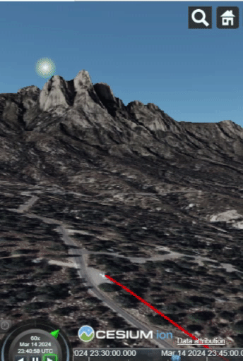
Here's the activation in Cesium so you can see where the sun was in relation to the QSO. The QSO takes place at 14:49 near the end of the animation.
I completed the first prototype of my CZML QSO mapping template for Datasette yesterday.
So far, I've implemented animation by using the interval property in CZML. Intervals can be attached to any (?) other tag it seems. I had to intuit what to do on a large degree based on the documentation.
The inference that the viewer (happily) made was that if the show property was true in the interval, then it must be false the rest of the time. (The default value of 'show' is true, so I was quite pleased with this implementation instead of the alternative where I might have had to define intervals for when I wanted the line turned off. This solution is far more intuitive to me.
I like several things about how this worked out with Cesium as opposed to other geospatial solutions available on the web. First, Cesium has animation available directly on the web as opposed to a desktop application.
Second, the player controls are available to the user and the player time range is specifiable in the CZML file, like this:
The "clock" "interval" specifies the entire time available to the player. I need to modify my template a bit to make the beginning of the interval, (which is the time of the QSO at the moment), match the currentTime, (which is a few minutes earlier to provide a runway into the animation.) I suspect this may be what's causing me to have to click the play button twice to start the animation.
The final nice feature I'll point out today is that the Cesium Sandcastle makes it easy to play and experiment with both CZML and using JavaScript to control the viewer. You can even import CZML into Sandcastle sessions using the viewer's load method and statically hosted files. I used github as an easy platform to serve files from. (Keep in mind that new commits to files take about a minute to reach the raw page.)
On the downside, the documentation for CZML took me a while to get used to and required several mental leaps and experiments, some of which were incorrect.
Oh! And it turns out you can share and embed slide shows. I'm not an expert at these yet, but they seem promising.
I'll have more details soon. For now, here's the template.
Check out the sun going down over the Organs as the POTA progresses! So Cool!!!
NOTE: If you're on a cell phone, first zoom the globe in until you can't see the edges of the Earth. At that point, the terrain should become visible. It appears to be a Cesium issue, but it's easily worked around.
I had a little time to play with a new mapping app over the weekend!
This one is from Cesium and in its native form uses a JSON derivative called CZML. CZML is similar to KML. Furthermore, while it won't animate kml for me (at least not yet), CZML looks like it will support timestamps and animation. So! Maybe there'll be a new plugin for the logging program this week.