Normal view

There are new articles available, click to refresh the page.
Before yesterdayCopasetic Flow

LobsterCon Travelog

We're on the East Coast! KO6BTY, myself, and the 9 year-old, (known on the internets as Tawnse), flew out to Boston from San Francisco yesterday. We walked out of the airport to the ferry terminal! That's so cool! You can walk to a ferry from the airport. But do you know what we did then? We didn't take a ferry, we took a water taxi to a different ferry terminal! So many cool things already!

Here's the view from the water taxi.


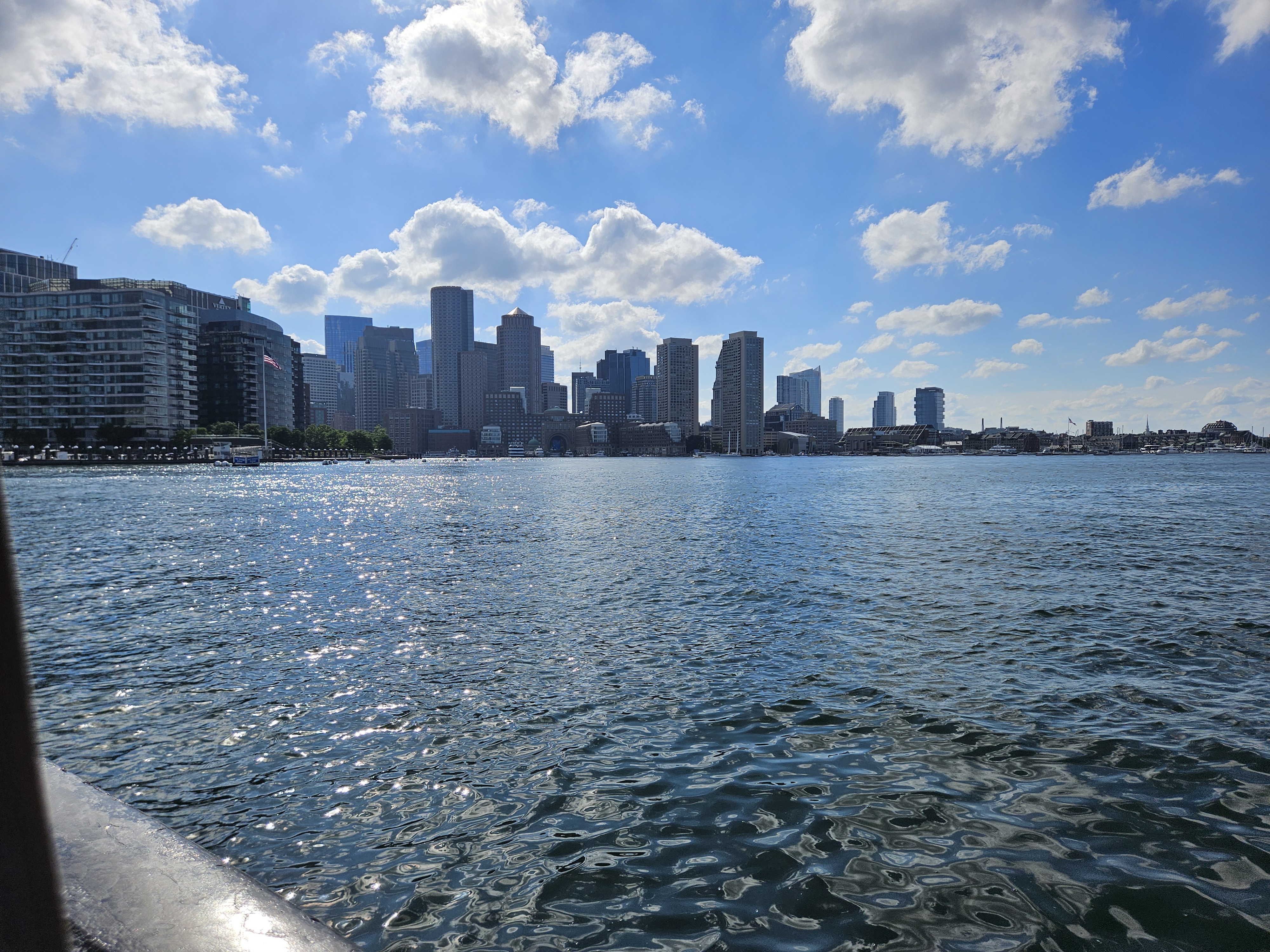
We landed at Rowes Wharf which seems to be one of the fanciest wharf's in Boston, so.. yeah. From there we caught the ferry southeast to Hingham 


and from there made it to our camp site at Wompatuck State Park.

We're now making our war around via public transit taking the T back in to Boston South Station to catch a train from South Station into Philadelphia.

Meanwhile! KO6BTY and I have had Cesium maps built into our QSO log for a few months now—ever since the day Simon Wilison nonchalantly pointed out that Datasette queries are URLs in an office hour we attended with him—but haven't put up a demo video! Here's a video of a few of KO6BTY's QSOs from one of our recent camping trips along with their associated F2 ionospheric skips.


Lab Notebook: The Rockmite isn't Transmitting

 KO6BTY took over debug implementation last night. She wired the RF out from the Rockmite directly to Project TouCans antenna out and... Nothing.

Looking at the schematic, that leaves a few choices for what's going on.

My favorite for the moment, because it's easy, and because the part is actually very bent, is the T/R switch transistor:


The transistor is a 2N7000 MOSFET. Wikipedia lists its maximum current as 200 mA and I can see where we could have exceed that when the Rockmite was shaking loose in TouCans (several of the nylon spacers sheered after a fall.) Also, keep in mind that the power bump has more current traveling through this part of the circuit in any event.

After that, we'll be looking at whether or not the oscillator is still oscillating. But actually! Good news! If the oscillator weren't oscillating, the receive branch also wouldn't work, and it most certainly is working!


Lab Notebook: TouCans Debug It Wasn't the RockMite PA Transistor

Since we returned from camping, Project TouCans has been pretty much off the air. We still have receive, a keyer, and a sidetone, but the rig just isn't transmitting.

Last week I thought the issue might be the output transistor of the RockMite. It is not. I removed the original transistor, replaced it with a new one, and to no avail! Here's the before


And after


There was no change in the operation of the rig. No signals were spotted by the RBN or either of the Utah or Half Moon Bay SDRs.


Robot Dreams, Summer Camp, and Public Transit

 Just a quick note. 

My partner and I went to see Robot Dreams with the 11 and 9 year olds about a week and a half ago. First, the movie is awesome! It stays almost true to the book in that there are very, very few words at all. More in the movie than there ever were in the book, but still. The whole thing was a lot of fun and I highly recommend it.


The oldest kid wasn't there because she was attending summer camp up on the orthern edge of the penninsula. 

After the movie, my partner and I went off to do errands in one direction, the 11 and 9 year old headed  towards the house on BART. And! Guess what?

They ran into their older sib on the bus home. There routes coincidentally linked up for the last leg and they hopped on the sam bus she was on. About a stop later, they all realized it.

Public transit and independent kids are pretty awesome! We got to do our errands. The kids got to go do what they wanted, and they ran into each othere anyway! Without transit, I doubt we could have even seen the movie because we'd have been making camp pickups and whatnot. Woooo MUNI and BART!


Antipodal HF Radiation: Or How Did TouCans Talk to Nighttime Australia and Japan after Sunrise in CO?

 On one of the most interesting radio days of our recent camping trip, Project TouCans made QSOs with Australia, Japan, Columbia, and Argentina, all on the same day! The QSOs to Japan and Australia were made in the middle of their night. The Japan, Australia, and Columbia QSOs were all made in a sixteen minute window beginning with VK3YV at 12:40 UTC.


What was the Propagation Mode?

While the QSOs were awesome! How did they happen? I did a bit of research. 

Spoiler: I don't have an answer yet.

If you have ideas, I'd love help on this, please comment!

Dayside stations talking to nightside stations led me to sv1uy's page on chordal hop propagation which had a nice diagram


The rest of the notes from below followed from this diagram. I don't have answers yet, but here are my notes. I've been talking with the kids about radio occultation, refraction, and of course, the Gladych research project during all of this. I'm also using it to introduce trig which will layer in with the work the 11 and 9 year-olds, (Mota and Tawnse), are doing with fractions.

This mode, (numbered page 4 of Gold's thesis), is interesting because we had plenty of scattering. Notice the mountain peaks and ridges all round us below.


Chordal Modes Introduced with Villard

And we have our first reference to Villard, which included Okinawa, and therefore two different Gladychs, Michael's Project Smoke Puff article, and Stanislaw who was the architect for the Okinwa base in 1955.


And there's a bit of a Gladych aside here that's just too difficult to ignore. Apparently Stanislaw also few planes in World War II? I knew Michael did, but this is the first mention [pdf] I've seen of Stanislaw being a pilot


Carter Manny Jr. worked with Stanislaw. Here's his Chicago Tribune obituary.

Finding Our Antipodal Point

To find the anitpoidal point, we can follow our longitude over the North (or South for that matter) where it will become the same longitude minus 180 degrees, or pi radians if that's the unit you prefer. You can see this in the diagram below where our longitude of about -107 degrees traced over the pole becomes about 73 degrees.


Meanwhile, our latitude above the equator will be used to find the same number of degrees below the equator:

37.82275 becomes -37.82275.

More precisely, we get 

37.822754°N 107.717935°W -> 37.822754°N 72.282065°E


And our anitpodal is shown below near the 70 degrees East label.


Pretty excellent discussion of anitpodal points.

Conclusions for the moment

I don't know what propagation mode we had yet. We're going to pull some ionosonde data next to see if there was in fact a 'tilt' in the ionosphere at the time of the QSOs.


Project TouCans featured on Ham Radio Workbench Episode #211 !!!


A few weeks ago, the 13, 11, and 9 year-old gang and I were out on our yearly camping trip, hanging out near Great Basin National Park above Baker, NV, when KO6BTY and I got to participate in a Ham Radio Workbench episode! It was a lot of fun! (It was also one of the latest nights up we had during the trip.)

If you're landing here from there, we talked about a lot of things including:

Project TouCans (page) (and in general)

POTA/SOTA

How early versions of TouCans were inspired by the OHIS

Camping

KO6BTY and my writing projects regarding one Michael Gladych (page) (general gladych) (general history of physics)

unschooling/homeschooling/parenting in general

and we got to talk to Thomas K4SWL about qrp rigs


We just made it back from our camping trip yesterday, so I hope to have a lot of updates over the next few days, and maybe some pretty pictures as well like this one of Mt. Wheeler and, of course, Project TouCans.


A View to an F2 Skip

 The fact that KO6BTY and I both made our POTA contacts with Japan while it was still very much nighttime in Japan, fascinates me. Here's what my QSO with JG0AWE looked like with respect to the night sky and the grey line.


K06BTY's QSO was even earlier in the morning for us, so even further from sunrise in Japan.


Threading the Valley: Australia from Colorado on 20 meters and 5 Watts with Project TouCans

 The gang and I made our first QSO with Australia this week!

The QSO came bundled with two other DX contacts made with Project TouCans—all in a 16 minute window—which I'll write about soon. Our camping site is nestled below Anvil Mountain to the East and across the Million Dollar Highway from South Mineral Springs, about two miles north of Silverton, CO. We're surrounded by peaks on all sides. Bear Mountain peak is framed in my pictures of the rig.

Project TouCans was probably 20 feet up in its dipole. This turned out to be difficult to show in photographs with the proper perspective. I finally decided to make a gif of different zoom levels of a single photo. The picture below starts out focused on Bear Mountain Peak and then zooms out to include the rig and the ground outside my partner's and my tent.


You can see the Bluetooth transmitter that brings the head phone audio down to the ground hanging from the bottom of the rig.

The campsite is gorgeous and almost completely bug free. I managed to make it out on one hike. Tawnse—the nine year-old—our puppy, and I were treated to views like this


Notice the mountains lurking very nearby in every shot.

That brings us to the circumstances of the QSO with VK3YV, the first DX QSO of that morning. Here's our campsite from a way's out showing the F2 skip path (estimated using real-time data from the Boulder, CO ionosonde), as well as the path of the QSO along the ground. 


Zooming in a bit reveals just how many peaks we were surrounded by and shows our location relative to Silverton.

So, with all those mountains in the way, how did we talk to Australia?

Project TouCans threaded the valley to the west of our campsite! Check this out!

I'll leave you with the map of the QSO so you can trace along the path at your leisure. Use the time control in the lower left corner or the slider along the bottom of the map to locate the QSO at 12:40 UTC. From there, you can zoom in and out using a mouse center-button wheel. You can also tilt by holding down the control key, and then moving the map using the left mouse button.


Update

Due to a bug in the ionosonde code that I'd immediately introduced, the F2 layer height was not 307 km as shown in the diagram above. It was in fact, 235 km over Hawaii which had data at the time, (Boulder, CO in fact did not), and which was closer to the middle of the QSO path as well. The difference in F2 height resulted in the first mountain intersection that used to look like this


with the incorrect data looking like this with the new F2 height data


References

Ionosonde Data

This was made possible with data collected by 

US-4408 Project TouCans POTA Activation Outside of Silverton, CO

 POTA activation from Silverton in twenty-one minutes!

Project TouCans had one of its highest ever antenna placements.


It showed in the QSO data. Check out the number of 599 reports, (white qso paths.)

(All QSOs are shown with their associated F2 skip paths.)

I'm loving the, (very real), yet very sci-fi look of what's going on with the F2 skips from this rig at this location


Most of the F2 paths actually cleared the mountain, so I didn't have to think about diffraction or other radio optics effects. VE3EID did plow just a little bit into the mountainside

It did come out the other side. (By the way, you can look at all of this on your own in the map below.)

But, if Ontario plowed into a peak a little bit, how did Puerto Rico KP3CW spot the rig? 

Turns out, it's line of sight between mountains from here


QSO Map

Here's the map you can steer around in on your own! Remember, click play in the lower left hand corner, then move the time slider all the way to the left. You'll be able to see all the QSO paths and their F2 skip paths (based on Boulder, CO ionosonde data at the time of the QSO.) If you click play again, you'll be able to see how the QSOs played out over time.


Notes

Difference in Altitude

I'm still working through getting the F2 traces to routinely emit from the ground. This time, Google Maps said the elevation here was 2982.468 m, but Cesium is happier with 2947.468 m, co about 35 meters lower than expected. Even then, we're not on the ground


SQL Query

select

  tx_lng,

  tx_lat,

  rx_lng,

  rx_lat,

  rm_rnb_history_pres.timestamp,

  rm_rnb_history_pres.dB,

  rm_rnb_history_pres.Spotter,

  haversine(tx_lat, tx_lng, rx_lat, rx_lng) as total_path,

  gis_partial_path_lat(tx_lat, tx_lng, rx_lat, rx_lng, 200) as el_lat,

  gis_partial_path_lng(tx_lat, tx_lng, rx_lat, rx_lng, 200) as el_lng,

  id,

  strftime('%Y%m%d', timestamp) as date,

  strftime('%H%M', timestamp) as time,

  'US-4399' as park,

  'KD0FNR' as call,

  'BC840' as ionosonde,

  2947.468 as elev_tx

from

  rm_rnb_history_pres

where

  dB > 100

  and timestamp > '2024-05-29'

  and timestamp < '2024-05-30'

order by

  rm_rnb_history_pres.timestamp desc

SQL Query for RBN and QSOs

Due to a bug/oversight in the system, I have to run with tx location coordinates set in the query when I want to include RBN spots, so here's that query

select

  -107.7179358 as tx_lng,

  37.8227611 as tx_lat,

  rx_lng,

  rx_lat,

  rm_rnb_history_pres.timestamp,

  rm_rnb_history_pres.dB,

  rm_rnb_history_pres.Spotter,

  haversine(tx_lat, tx_lng, rx_lat, rx_lng) as total_path,

  gis_partial_path_lat(tx_lat, tx_lng, rx_lat, rx_lng, 200) as el_lat,

  gis_partial_path_lng(tx_lat, tx_lng, rx_lat, rx_lng, 200) as el_lng,

  id,

  strftime('%Y%m%d', timestamp) as date,

  strftime('%H%M', timestamp) as time,

  'US-4408' as park,

  'KD0FNR' as call,

  'BC840' as ionosonde,

  2947.468 as elev_tx

from

  rm_rnb_history_pres

where


  timestamp > '2024-05-29'

  and timestamp < '2024-05-30'

order by

  rm_rnb_history_pres.timestamp desc

References

Ionosonde Data

This was made possible with data collected by 


Low Slung Dipoles and How Project TouCans Reached California from US-5906 on a POTA by a Cliff

 We got to camp a bit more in the middle of nowhere than we usually do while traveling across Utah last weekend. My partner found the Burr Trail Scenic Byway. I've looked for a route across southern Utah for the last several years, but had somehow missed this really nice, well-paved, little road.

We camped at the foot of an East-facing cliff, and the QSO map for the POTA reflected that fact pretty nicely:


Based on this overall map, I didn't think we could hit the West Coast because of this cliff face.


Almost all of the QSOs and spots paid attention to that cliff face. And then, there was N0OI:


How? How had the signal cleared the cliff and skipped out to Perris, CA?

Using data from the Boulder, CO ionosonde, at the time Project TouCans was spotted in California, the F2 layer skip is modeled in the gif below. Note that it clears the mesa, (just barely.)


The other skip off to the Southeast was headed to the Cayman Islands. All of the skewing around is to convince myself that the the F2 path lines up with the path to the spotting station. You'll notice that there's a slight elevation offset that needs to be fixed.

More Notes on the POTA

I blew out my knee a bit sitting on the ground outside the tent for a three hour podcast interview on Friday night, consequently, the gang did most of the station set up including deploying Project TouCans in its dipole. Throughout that process, the family pup kept me company

When the gang were done, we had what, for Project TouCans, was a fairly typical antenna height of about five feet over the ground

One really interesting aspect of this POTA was that I didn't have the ability to Internet spot myself. Frankly, I wasn't sure it was going to work out at all, and for the longest time from about 00:02 GMT 24-05-27 till 13:50 GMT on the same day, it didn't. (Yes, I was asleep for most of that time with the rig turned off.) And then! Thanks—I think—to a few neighboring POTA stations, ops started to realize that TouCans was there! It may have also helped that my first QSO with WI5D was a bit of a rag chew.

Also, while hanging out on the cliff, the gang found an interesting mineral/quartz/mica/I don't know sample of rock. It was flat, broke easily, and contained pockets of crystals that were translucent. Any ideas what this might be?


For the moment, I'll leave you with this map of all the spots and QSOs for the POTA over the course of the evening, and into the next morning. Click play, then move the time slider all the way back to the left to see all the spots and QSOs with their associated F2 skips at once. Then, you can hit play to see how it all unfolded. (Keep in mind, the overnight nothingness is included in the map. You may want to skip over that.)


As a final note, while I'm waiting for all the F2 data to come back, I've been trying to convince the gang that the F2-height datastream from the Boulder, CO ionosonde 


is in fact entered manually by a room of accountants not unlike those in John Wick, but to no avail. I guess they're just digital natives :) 


Ah! And credits to where the ionosonde data actually is coming from

This was made possible with data collected by 


More F2 Skip Cesium Development Notes

 Here's the query I'm using for Burr Trail


============================================

select

  tx_lng,

  tx_lat,

  rx_lng,

  rx_lat,

  rm_rnb_history_pres.timestamp,

  rm_rnb_history_pres.dB,

  rm_rnb_history_pres.Spotter,

  haversine(tx_lat, tx_lng, rx_lat, rx_lng) as total_path,

  gis_partial_path_lat(tx_lat, tx_lng, rx_lat, rx_lng, 200) as el_lat,

  gis_partial_path_lng(tx_lat, tx_lng, rx_lat, rx_lng, 200) as el_lng,

  id,

  strftime('%Y%m%d', timestamp) as date,

  strftime('%H%M', timestamp) as time,

  'US-4399' as park,

  'KD0FNR' as call,

  1770.829467773438 as elev_tx

from

  rm_rnb_history_pres

where

  dB > 100

  and timestamp > '2024-05-27'

  and timestamp < '2024-05-28'

order by

  rm_rnb_history_pres.timestamp desc

=======================================================


At some point I'll add an ionosonde field using this map for each QSO. For the Boulder, CO ionosonde, the query will look like

=========================================================

select

  tx_lng,

  tx_lat,

  rx_lng,

  rx_lat,

  rm_rnb_history_pres.timestamp,

  rm_rnb_history_pres.dB,

  rm_rnb_history_pres.Spotter,

  haversine(tx_lat, tx_lng, rx_lat, rx_lng) as total_path,

  gis_partial_path_lat(tx_lat, tx_lng, rx_lat, rx_lng, 200) as el_lat,

  gis_partial_path_lng(tx_lat, tx_lng, rx_lat, rx_lng, 200) as el_lng,

  id,

  strftime('%Y%m%d', timestamp) as date,

  strftime('%H%M', timestamp) as time,

  'US-4399' as park,

  'KD0FNR' as call,

  'BC840' as ionosonde,

  1770.829467773438 as elev_tx

from

  rm_rnb_history_pres

where

  dB > 100

  and timestamp > '2024-05-27'

  and timestamp < '2024-05-28'

order by

  rm_rnb_history_pres.timestamp desc

limit 1

====================================================================

The extra ionosonde field works!!! 

References

Ionosonde Data

This was made possible with data collected by 


Things I (didn't) Learn (yet): Setting Elevation of Line Endpoints in Cesium CZML

 The F2 skip traces in Cesium have looked a bit odd:


Whyyyyy?????

It's because they're starting from sea level, not the altitude of the station.... I think... What follows are somewhat random development notes.

Relative to Ground: True, Alt: 0


Relative to Ground: True, Alt: 3600 meters


Relative to Ground: True, Alt: 1772.717


Almost!!!

Relative to Ground: true, elevation: 1770.829467773438


I got the more accurate elevation from the elevation plugin using:
{{ tx_lat }},{{ tx_lng }}|{{ rx_lat }},{{ rx_lng }}


Not quite there yet....
To get this close, I had to run with 


But the CZML schema says:

So, it seems like the correct altitude in this case should be 0. (Start the line on the ground.) But, if I put in zero for altitude, I get the result shown above


Found a reference to quaternions. Ahhhh, quaternions.


References

Ionosonde Data

This was made possible with data collected by 


Ionogram Notes about KO6BTY de JJ2JQF

 The recent pair of QSOs to Japan from Project TouCans from Great Basin National Park has me wondering about F2 layer ionospheric skip propagation again.

I got our F2 skips working for CZML. Here's a look at the skip path for JJ2JQF de KO6BTY. Notice the Earedson ionosonde is almost right in the middle


Here's the map to take a look at 


Note that the path goes for a little while underground. However, Hugyens:


Check out the mountains that can act as a knife-edge barrier creating  new source.


Query for JJ2JQF

select
  tx_lng,
  tx_lat,
  rx_lng,
  rx_lat,
  rm_rnb_history_pres.timestamp,
  rm_rnb_history_pres.dB,
  rm_rnb_history_pres.Spotter,
  haversine(tx_lat, tx_lng, rx_lat, rx_lng) as total_path,
  gis_partial_path_lat(tx_lat, tx_lng, rx_lat, rx_lng, 200) as el_lat,
  gis_partial_path_lng(tx_lat, tx_lng, rx_lat, rx_lng, 200) as el_lng,
  id,
  strftime('%Y%m%d', timestamp) as date,
  strftime('%H%M', timestamp) as time,
  'US-0032' as park,
  'KD0FNR' as call
from
  rm_rnb_history_pres
where
  dB > 100
  and timestamp > '2024-05-24T13:45:00'
  and timestamp < '2024-05-24T14:57:00'
order by
  rm_rnb_history_pres.timestamp desc


Query for JG0AWE

select
  tx_lng,
  tx_lat,
  rx_lng,
  rx_lat,
  rm_rnb_history_pres.timestamp,
  rm_rnb_history_pres.dB,
  rm_rnb_history_pres.Spotter,
  haversine(tx_lat, tx_lng, rx_lat, rx_lng) as total_path,
  gis_partial_path_lat(tx_lat, tx_lng, rx_lat, rx_lng, 200) as el_lat,
  gis_partial_path_lng(tx_lat, tx_lng, rx_lat, rx_lng, 200) as el_lng,
  id,
  strftime('%Y%m%d', timestamp) as date,
  strftime('%H%M', timestamp) as time,
  'US-0032' as park,
  'KD0FNR' as call
from
  rm_rnb_history_pres
where
  dB > 100
  and timestamp > '2024-05-24T13:45:00'
  and timestamp < '2024-05-24T14:57:00'
order by
  rm_rnb_history_pres.timestamp desc


And the data went away!


Notice that the table on the left isn't there. Take a look at the JJ2JQF data (two days later) for comparison


Sources of Ionosphere and specifically F2 data from around the world

New to me: Mirrion ionosonde images from NOAA. I haven't seen this page before. Not super-useful to me because it points at images, not numeric data.

Lowell Digisonde Station list: Handy map of where stations exist.

CZML and HTML style comments

Apparently, they just don't work. We had to take our comments back out.

Accessing data via URL

We use an address like this

https://lgdc.uml.edu/common/DIDBGetValues?ursiCode=PA836&charName=hF2,hmF2&fromDate

to pull in ionosonde data. To access different stations, you need different ursiCode values, (one per station.) These can be found at https://www.digisonde.com/ under the URSI column.

This URL worked great in the browser, but thanks to this issue, stumbled a few times in the czml plugin's calls to get_f2m.

References

Ionosonde Data

This was made possible with data collected by 


Japan Two Days in a Row and KO6BTY's first POTA Activation from US-0032 Great Basin National Park

 Today KO6BTY made a QSO to Japan from Great Basin National Park!!!


Not only that, but she also made her first POTA activation! She was operating from Project TouCans as KD0FNR/KO6BTY on 20 meters. Here's the QSO map, (after hitting play in the lower left corner, all the QSOs will shown for a brief moment; if you click pause you can zoom in/out and view all of them at once; continuing with 'play' will remove all QSOs and display each QSO as it happened in time during the activation):


We Must Be in Nevada... QSO de JG0AWE!!!


This morning at the 2nd POTA activation here, I got to talk (OK, CW), with JG0AWE again!

Just like last year!

I was using a bit more power this year. Project TouCans is running somewhere between 3 and 5 Watts at the moment.

He caught me just before the gang go the oatmeal ready, (we're camping on the edge of Great Basin National Park), On top of that, a RBN station in Japan had spotted Project TouCans about half an hour before. There wasn't a grey line between our locations, so I'm curious about what was going on, but delighted to have made the QSO!

Here's the activation in Cesium so you can see where the sun was in relation to the QSO. The QSO takes place at 14:49 near the end of the animation.

This one Weird Trick Reduces 2 S Units of Noise

 Washi tape to the rescue again!

Tuesday morning, with Project TouCans working better that it had in days, I noticed that the ends of our stranded wire antenna had begun to fray out. I grabbed a roll of washi tape from my pocket, (who doesn't take washi tape on a radio outing?), and a few minutes later, voila


The end of our antenna was no longer frayed, and nosie was down significantly! Here's a view of our activation site from the opposite angle looking out over the Great Basin of Great Basin National Park US-0032.


Twenty meters looking pretty good this morning

 The band's looking alright to Project TouCans this morning!


The map covers the following half hour table. Project TouCans is still running five watts or less.

 spotter  spotted distance mifreqmodetypesnrspeedtimeseen
  K3PA-1  KD0FNR/61360 mi14057.4CWCQ8 dB18 wpm1244z 17 May3 minutes ago
  ND7K  KD0FNR/6385 mi14057.3CWCQ7 dB18 wpm1244z 17 May3 minutes ago
  W6YX  KD0FNR/6207 mi14057.4CWCQ13 dB17 wpm1244z 17 May4 minutes ago
  W1NT-2  KD0FNR/62601 mi14057.4CWCQ8 dB17 wpm1243z 17 May5 minutes ago
  W1UE  KD0FNR/62579 mi14057.4CWCQ4 dB18 wpm1242z 17 May6 minutes ago
  KO7SS  KD0FNR/6533 mi14057.3CWCQ6 dB18 wpm1239z 17 May8 minutes ago
  TI7W  KD0FNR/62746 mi14057.4CWCQ8 dB17 wpm1238z 17 May10 minutes ago
  AC0C-1  KD0FNR/61376 mi14057.4CWCQ4 dB17 wpm1237z 17 May10 minutes ago
  ZF9CW  KD0FNR/62633 mi14057.3CWCQ9 dB18 wpm1237z 17 May11 minutes ago
  VE6WZ  KD0FNR/61154 mi14057.2CWCQ11 dB18 wpm1236z 17 May12 minutes ago
  W6YX  KD0FNR/6207 mi14057.4CWCQ12 dB18 wpm1234z 17 May14 minutes ago
  K5TR  KD0FNR/61272 mi14057.4CWCQ5 dB17 wpm1234z 17 May14 minutes ago
  ND7K  KD0FNR/6385 mi14057.3CWCQ12 dB18 wpm1234z 17 May14 minutes ago
  K3PA-1  KD0FNR/61360 mi14057.4CWCQ10 dB17 wpm1233z 17 May14 minutes ago
  W1NT-2  KD0FNR/62601 mi14057.4CWCQ4 dB17 wpm1232z 17 May15 minutes ago
  W4KAZ  KD0FNR/62261 mi14057.3CWCQ6 dB18 wpm1232z 17 May16 minutes ago
  K6FOD  KD0FNR/6118 mi14057.4CWCQ4 dB17 wpm1231z 17 May16 minutes ago
  W3OA  KD0FNR/62145 mi14057.4CWCQ4 dB17 wpm1231z 17 May16 minutes ago
  ZF9CW  KD0FNR/62633 mi14057.4CWCQ6 dB17 wpm1230z 17 May18 minutes ago
  KA7OEI  KD0FNR/6569 mi14057.4CWCQ16 dB18 wpm1229z 17 May19 minutes ago
  KO7SS  KD0FNR/6533 mi14057.4CWCQ6 dB18 wpm1228z 17 May20 minutes ago
  VE6WZ  KD0FNR/61154 mi14057.3CWCQ12 dB17 wpm1226z 17 May22 minutes ago
  N0OI  KD0FNR/6161 mi14057.4CWCQ7 dB17 wpm1225z 17 May23 minutes ago
  W6YX  KD0FNR/6207 mi14057.4CWCQ12 dB17 wpm1224z 17 May24 minutes ago
  ND7K  KD0FNR/6385 mi14057.4CWCQ8 dB18 wpm1224z 17 May24 minutes ago
  AC0C-1  KD0FNR/61376 mi14057.4CWCQ7 dB17 wpm1223z 17 May24 minutes ago
  K3PA-1  KD0FNR/61360 mi14057.4CWCQ12 dB18 wpm1223z 17 May24 minutes ago
  WA7LNW  KD0FNR/6348 mi14057.4CWCQ6 dB17 wpm1223z 17 May25 minutes ago
  K5TR  KD0FNR/61272 mi14057.4CWCQ6 dB18 wpm1223z 17 May25 minutes ago
  TI7W  KD0FNR/62746 mi14057.4CWCQ5 dB17 wpm1223z 17 May25 minutes ago
  KA7OEI  KD0FNR/6569 mi14057.5CWCQ28 dB18 wpm1218z 17 May30 minutes ago
  W8WWV  KD0FNR/62078 mi14057.4CWCQ5 dB18 wpm1218z 17 May30 minutes ago
  VE6WZ  KD0FNR/61154 mi14057.4CWCQ11 dB21 wpm1215z 17 May33 minutes ago
  K7CO  KD0FNR/6530 mi14057.5CWCQ2 dB21 wpm1215z 17 May33 minutes ago
  W6YX  KD0FNR/6207 mi14057.5CWCQ18 dB20 wpm1213z 17 May34 minutes ago
  ND7K  KD0FNR/6385 mi14057.4CWCQ3 dB21 wpm1213z 17 May34 minutes ago
  K3PA-1  KD0FNR/61360 mi14057.5CWCQ17 dB20 wpm1213z 17 May34 minutes ago
  WA7LNW  KD0FNR/6348 mi14057.5CWCQ7 dB20 wpm1213z 17 May35 minutes ago
  AC0C-1  KD0FNR/61376 mi14057.5CWCQ13 dB20 wpm1213z 17 May35 minutes ago
  K5TR  KD0FNR/61272 mi14057.5CWCQ9 dB21 wpm1213z 17 May35 minutes ago

Project TouCans is Back!

 The rig is back up and running.

I made two QSOs last night from the home QTH with a lot of noise! They were to KA6JLT in Reno, NV and and WN1Z in Susanville, CA from here in San Francisco.

This time, we did not measure the power out of Project TouCans. I suspect our several decades old Radio Shack power meter has given up the ghost, or there's something wonky in one of the cheapo connectors from Amazon.

As a side note, the radio is much quieter and works better when the RF output leads are soldered directly to the banana binding posts at the top of the rig that the antenna attaches to.

Side, side note. KO6BTY and I need to keep a slightly cleaner workbench. The rig sparked and vaporized a stray shred of wire yesterday once when we powered it up.

Project TouCans Workbench
Project TouCans Flies Again

Amateur Radio Posts from Around the World (or at least the Bay)

 Reading up on the Tuna Topper and funding for amateur radio projects

Since we're now blowing FETs on Project TouCans, and KO6BTY and I are giving a presentation about the rig to the San Francisco Amateur Radio Club on Friday, I've been reading up on amplifier theory. I really like this article explaining how the different classes of amplifiers work except for the horribly gendered  first paragraph.


In other reading news, (it's finals week for KO6BTY and I'm getting ready for our camping trip, so mostly all I've had time to do over the last few days is read), Simon Willison pointed out that the Amateur Radio Digital Communications group has grants for advancing the usage and technology of amateur radio. Here are some examples of what's been funded.

And finally, here's a link to the article that taught me how to increase power output on the Tuna Topper by upping the bias voltage. It's an even more cool article now that I know how the calls A Tuna Topper amplifier actually works.

To wrap things up, we're hoping to get TouCans back up and running today. Here's a nighttime look at the rig from the ground. The white object is the 10 meter rig's balun.


❌
❌