❌

Normal view

There are new articles available, click to refresh the page.
Before yesterdayThe Long Green Tunnel

HL/SL-006 Guryongsan

By: Jeff
9 May 2024 at 21:54

Β It was getting close to the end of our time in Korea, but there was still time for one more SOTA activation. We were back in Seoul, so I picked a summit that was easy to get to from the subway. This peak is south of the Gangnam neighborhood, made famous by the song.

The trails were well signed, and seemed pretty popular.

From the Yangjae Citizens Forest station exit 3 I walked south along the road. There is a busy road to cross, then a few buildings, then I stepped into the woods. Based on the maps I was expecting a well marked trail. But instead I found an unmarked, not well used path. It was going the right direction, and in the spot I expected, so I followed it. After a quarter mile or so it intersected with a much nicer path.
Occasional glimpses of the city.

This trail was obviously what I wanted, and what I had been expecting, so I followed it up the ridge. There were a fair number of people out for a hike. Like the other hikes I had done here, it was much more humid than I was expecting. I'm really spoiled living in California. It did feel like it was going to rain, but I never felt more than a few drops.Β Β 
Weather station on the ridge.

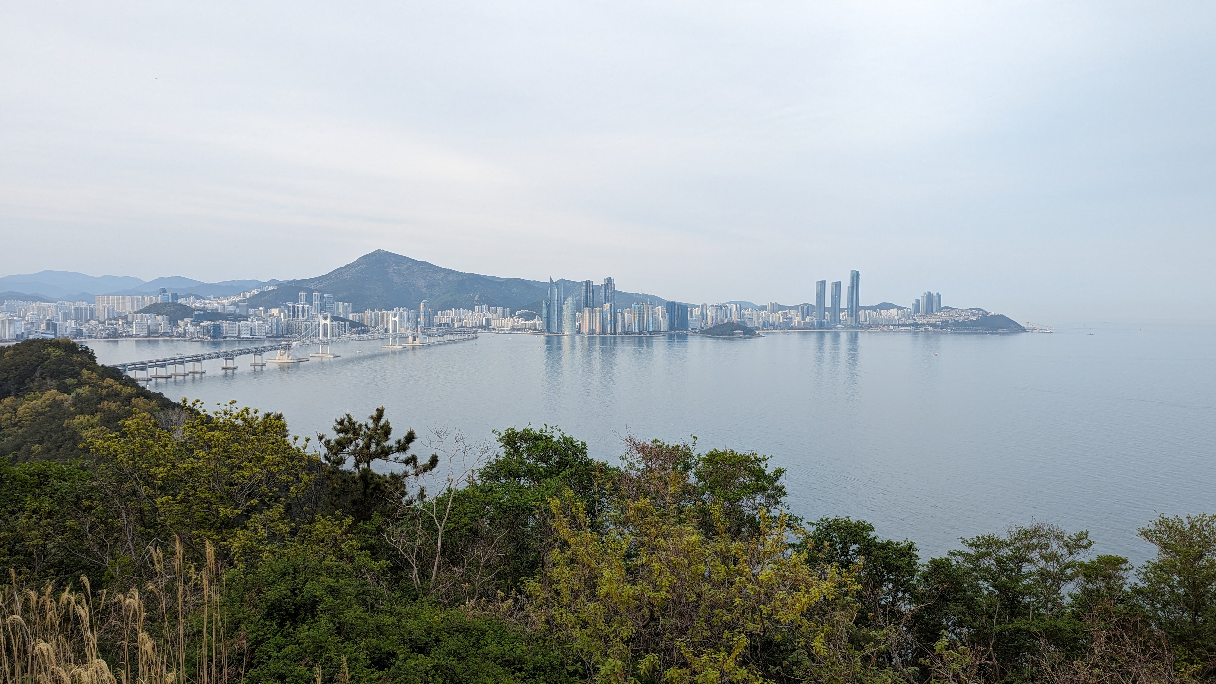
At one of the intersections there was a big sign telling about the Seoul Trail that circumnavigates the city. It seemed like it could be an interesting thing to do if you lived there. Shortly before the summit is an excellent view point. I stopped for a few pictures before continuing on to the high point. The summit was unremarkable. Just below, near a tower, was a bench I decided to sit at. It was slightly difficult putting up the antenna through the trees, but I managed well enough. On the air I worked Korean and Japanese stations.Β Β 
Seoul: Namsan on the left, Lotte Tower, Bukhansan

Once HF was packed up, I walked back to the viewpoint to see if I could get anyone on 2m. I got two more stations, then headed back down. This time I took the nice trail all the way to the bottom, where it came out between a few buildings. It would've been hard to find that trailhead without knowing about it.Β 
Trailhead:Β Yangjae Citizens Park subway station, exit 3.
Website:Β SOTA Site.
Route:Β Head south along the road, crossing the expressway. In between the buildings there is a trailhead, or the one along the main road. Follow the trail to the summit.
Red Tape:Β None.
Video:Β 

HL/BS-026 Jangsanbong

By: Jeff
2 May 2024 at 19:36

Β During our Korea trip we spent a few days in Busan. This lovely city is nestled among the hills on the southeast coast of the peninsula, and as you'd expect for a hilly city, has some good SOTA opportunities. Naina was in need of a nap, but I had plenty of energy, so I headed out one afternoon for a walk up a local peak. I chose Jangsanbong because it was reasonable close to a subway stop on the 2 line, and our hotel was also on the 2 line.

From Haeundae Beach, I think thats the summit I went to.

We only got one SIM card for the trip, and it was in Naina's phone, so I had to navigate the "old fashioned" way, with just the maps downloaded to my phone. It was not hard, since the phone maps will show you where you are using GPS. I got off the subway at the Kyungsung Univ.-Pukyong Nat'l Univ. stop, then went out exit 3. A u-turn at the top of the stairs then left turn had me heading down the right road.
The summit hiding behind the buildings.

I walked past Pukyong National University, following the main road. At a three way intersection I didn't have to cross, and beared left. Shortly after this there was a busy expressway crossing, so I had to wait for the walk signal. The area on the ocean side of the expressway was much less busy, and felt less built up. The road kept getting smaller and smaller, until it was two lanes with no median. I crossed at a crosswalk shortly before the sidewalk ended.
Helpful(?) map of the park and mountain. I followed the green path, more or less.

As you pass the last buildings, the road gets much steeper. Some meters of climbing later I passed a nice looking building, then a parking lot. There are bathrooms in the building, which was nice, and at the far corner of the parking lot was a trailhead. It was late Sunday afternoon, but the lot was nearly full, and I saw many people out in the park. After a quick glance at a map board, I decided it would be easier to just follow my phone.Β 
Paved trail on the way up.

The trails in the park had impeccable maintenance. The steep parts were paved or had steps, and the trails were wide. It was nice to be off the city streets. At the top of the first climb, where I got onto the ridge, there was a free outdoor gym. People were using it. This was to become a theme. I followed the main trail up the ridge. Every once in a while there would be a small gap in the trees and a view of Busan, but don't come here if you're expecting views.Β 
Marker at the summit. I'm not sure what its marking though.

Just below the summit there is a turn off to the high point. I walked through another gym, also in use, to the summit which was an open field. There was a big X in the field, with a path around the perimeter. There are some benches next to the main trail at the junction, in the activation zone, but I decided it would be easier to put up a wire in the open field on top. I used the bushes to hold the pole, and was soon on the air. I thought I'd get a lot of Japanese stations on 40m, but I only got two. I was getting worried as I switched to 20m, but it turns out 20m was probably a better band for getting Japan. I also managed to get a chaser in New Zealand.Β 
Views of Suyeongman Bay and Busan. Haeundae Beach is on the right, below the three towers.

Once I had packed up I took the same route back down. I passed a viewpoint I had missed on the way up, and that small detour was worth it. The trees had been cleared enough to see the harbor, Hauendae Beach, and parts of downtown. The soft evening light made the scene beautiful. I managed to get through the city, ride the subway, and get back to the hotel just before dark. Though I wasn't too worried once I got to the streets since I knew they'd be lit.
Post-activation soju.

Trailhead:Β I started at the Kyungsung University stop on subway line 2, but if you have a car you can get much closer.
Website:Β SOTA Site.
Route:Β From the Kyungsung University stop on subway line 2, follow the main road towards Pukyong University, across the expressway, and up past the church to the parking lot. Then take the main trail up to the summit.
Red Tape:Β None.
Video:Β Coming soon.

HL/SL-009 Namsan

By: Jeff
29 April 2024 at 18:01

Β We were in Korea for vacation, so naturally I wanted to do some SOTA. Korea is a mountainous place, and it looked like there were plenty of choices. The first summit we did is in the middle of Seoul, literally. The geographic center of the city is on the side of the plaza on top.

The tower is visible from a lot of places in the city, including this traffic island in Myeongdong.

Our hotel was in the Myeongdong neighborhood, near the Hoehyeon subway station. From exit 1, head uphill through the neighborhood. There was a flight of stairs just below a busy road, which we crossed to enter Baekboem Plaza. The tower on top was visible from here, and it was easy to follow the path to the bottom of the staircase.Β 

From the plaza. Still some blossoms on the trees!

Since the summit is easy to get to in a big city, there were a lot of people out. The stairs up to the top were wide and paved. There are plenty of benches, and even a few viewing platforms on the way. It was hazy as we ascended, but we could still see Bukhansan a few kilometers away to the north. We were glad it was cool out, it probably would have been a miserable hike in the summer.
Base of the stairs.

You know you are close when you see the cable car terminal. This is also where it goes from busy to crowded. Once you make it up the last few stairs, there are plenty of benches around the plaza and under the structure. We sat for a few minutes taking in the scene. On one side the fence is filled with locks that couples have attached. There was even a vending machine to buy your own to add.
High point of Namsan.

We found a bench out of the way, and I got on 2m. I had been warned that Korean hams are chatty, and they were. It took a couple of minutes calling CQ, but I soon had a long conversation with someone who couldn't quite get my Korean callsign (HL1/AA6XA). The slash seemed to trip him up. After a long chat I got two more stations in the log. Some more CQ calls didn't get anyone else, and we were getting bored and hungry, so I packed up. I thought about trying HF, but there really isn't anywhere to put up a wire without getting in people's way.

At the geographic center of Seoul.

We took the stairs back down, then turned onto a different road to get to the bibimbap restaurant near the base. It was a tasty and well earned lunch.Β 

Trailhead:Β We started from Hoehyeon Station exit 1, but there are myriad routes one could take
Website:Β SOTA Site.
Route:Β Make your way through the streets to the base of the stairs, then up the stairs to the summit. Or take the cable car.
Red Tape:Β None.
Video: https://youtu.be/PhfTnJKnz4U

W7I/SI-217

By: Jeff
13 January 2024 at 00:38

Β This little peak is across the road from Lava Hot Springs. Since it was the winter, and there was snow on the ground, I parked in the empty lot at the corner of Center and River streets. From here it was a short walk up River Street to Highway 30. After making it across, I walked up the dirt road to what seemed like a good spot to go up the railroad embankment. I crossed the tracks and was on my way.

Looking up, across the tracks.

The hike up the hill is steep. It was not, however, steep enough to need traction in the snow. Most of the hill just across the tracks is either State or BLM land, so no problems with access. And the scary cliffs you can see from the highway are easy to bypass. Near the top of the ridge I crossed a road, leading to a hut. It wasn't really the direction I wanted to go, so I continued up to the ridge, then across towards the summit.Β 

Nice views to the west on the way up.

It was a lot easier hiking on the ridge, since it was much less steep. The highest area had more snow, but not enough to make walking difficult. I tagged what appeared to be the high point in some rocks, then went over to find a spot to put up my antenna. On the air I made plenty of contacts, and had great cell service on top.Β 

Antenna on the summit.

Going down was easy, I just followed my footprints. The steep section was a lot more fun, since I could slide a little on each step to get down faster. At the bottom I carefully crossed the tracks and highway again, and walked back down the road to my car. Overall, it was a fun hike and a great day to be out in the mountains.


Trailhead: Big parking lot at the corner of Center St and River St. In the summer you can probably park on the dirt pullout by the tracks, across the highway.
Website:Β SOTA Site.
Route: Walk up River St, cross the highway and train tracks, then head straight up the hill. On the ridge, follow it over to the high point.
Red Tape:Β I didn't see any signs, so you're probably ok.
Video:Β Coming soon!

W7I/SI-190 Camelback Mountain

By: Jeff
6 January 2024 at 16:35

Β At first glance, there is no way to get to this peak without trespassing. However, intrepid hiker, this is a public way. A corner of BLM land crosses West Buckskin Road at approximatelyΒ 42Β°52'11.0"N 112Β°21'32.0"W. This is where you should park.

Heading up the hill.

Since it is only a narrow bit of public land at the road, you have to go straight up a rather steep hill. I lucked out and went after a few warm days had melted all the snow from this south facing slope, but it would be treacherous with snow or ice. After climbing a couple hundred feet in way too short a distance, you reach the top of the first hill. The summit is visible, as is the sub-peak you have to go over. Fun.Β 
At least there are nice views on the way up.Β 

There are no trails here, but the brush is easy to go through or around. The climb up the sub-peak is steep, maybe a little less than the first climb. On the top you have to drop again before the final climb. Its a real roller coaster of a hike. The final push isn't as bad as the first two.Β 
Looking south, I think.

The summit is long and narrow. It was pretty windy when I was up there, but the lee side of the hill was also the snowy side, so I decided it would be warmer to sit in the sun and wind. As I was putting up my wire, it broke at the feed point. I didn't want to take off my gloves, so I put it away and did an activation with only the whip. 20m was wide open, and I got a decent pileup. A few people got some extra QSB as the wind blew the whip over and I had to put it back to vertical.
I was able to fix it once I got off the mountain.

To get back, just retrace your steps. The downs seem even steeper than when you went up. Crazy how that is. Back at the road, with tired knees, I got back in the car and drove back into town. It was a fun hike. Maybe someday a spot with better access will open, but until then I'm glad there's a place it can be done from.


Trailhead:Β (42.86945, -112.35832). There is a pullout here with space for about two cars.
Website:Β SOTA Site.
Route:Β Head straight up the hill, staying on BLM land. Head over to the sub-peak, then up to the main summit.
Red Tape:Β I didn't see any signs by the road, but try to stay on public land.
Video:Β Coming soon!

W7I/SI-193 Chester Hill

By: Jeff
30 December 2023 at 19:37

Β Right after hiking and activating Rabbit Mountain I drove across Soda Springs to the end of North Main Street. There is a dirt lot at the very end of the street in which I parked. Next to the lot is a dirt recreation trail which travels around the base of the hill. Perfect for finding a good spot to head up.Β 

Looking back at the parking area.

I walked a short distance down the path before heading up the hill. There was a pullout in front of a fenced area, with open water behind the fence. Behind a concrete barrier with a "No Motorized Vehicles" sign was a use path heading up. I didn't see any tracks in the snow, but decided it was a good spot to head up.

Where I left the bike path and headed up the trail.

The trail climbed up, but never at an objectionable steepness. At a fence with an open gate another trail joined, and a single trail continued up the mountain. The trail first goes to a lower false summit with a big stone cairn on top. This seems to be where most people stop, since I didn't see a well worn trail after that.

Large cairn on the false summit. Some sort of power plant belching steam or smoke in the background.

From the cairn I dropped down a short distance to a wide, brush filled col. There were tracks across the brush, either from humans or animals. But either way, it made crossing pretty easy. On the other side I started climbing up to the summit. The top is covered in an open forest. I had no problem picking my way through the trees, and I think with some careful planning you could avoid the forest altogether.Β 

Going up through the woods.

There was enough of a clearing at the high point to put up an antenna, but I had passed a clearing with a view a few feet lower, so I backtracked a little before setting up. There was great cell service the entire hike. On the air I did only 20m again, since it was chilly. And like on Rabbit Mountain, there was a big pileup.Β 

Looking down at Soda Springs. (Or should we call it SOTA Springs?)

I took the same path back to the car. Not really any good options for a loop on this hill. From the base it was about an hour drive back to Pocatello and a warm shower.


Trailhead: Dirt lot at the end of North Main Street.
Website:Β SOTA Site.
Route: Take the bike path around to where you want to go up the hill, then follow one of the trails to the false summit. Cross the col, and head up through the woods to the high point.
Red Tape:Β Not signed anywhere.
Video:Β Coming soon!

W7I/SI-185 Rabbit Mountain

By: Jeff
30 December 2023 at 19:35

Β There are two SOTA peaks on either side of Soda Springs Idaho. This peak and Chester Hill. I drove out to these peaks for a double activation. First up was Rabbit Mountain. Following the advice of Bill N0DNF, I parked at the baseball fields in Kelly Park. At least I assume they were baseball fields, everything was covered in snow. Across the street I found a cross country trail, and started heading up.Β 

One of the signs. Skiing, disc golf, there was a lot going on there.

There is a small ridge that all the trails go around, to the right. I followed them around, then climbed up to the large water tank. The groomed and used section of ski trail seemed to end at the tank. After looking around a bit, I decided it would be easiest to just go straight up the hill, and that is what I did.

View from near the water tank.

The first part was through waist high grass. Where the hill got steeper, the grass ended and it was thigh high brush. Not hard to get through in the winter, but might be more of a challenge in the summer. The views did get better as I climbed towards a small wood at the top. It turns out the summit is through the woods and higher, but as you go up you can't see that.

View from the top. Low clouds the day I was there.

I was able to get through the woods without much trouble. There were a lot of deer tracks and other signs, so I just followed those where I could. Animals usually are good at finding the easiest way through. On the other side I found a road, and followed it to the towers.

I used one of the fences to hold up my pole, and got on the air. Since I didn't want to sit in the snow, I just kneeled in it. Not sure I stayed any warmer. With a big wire in the air I had a bigger pileup on 20m than I wanted, but I stayed long enough to work everyone.Β 

I retraced my steps back down the hill, more or less. In some places I thought I could find a shorter way down, but I don't think I saved any time. Back at the car I drove the five minutes across town to the trailhead for Chester Hill.

Trailhead: Baseball fields in Kelly Park. Near the end of Kelly Park Road.
Website:Β SOTA Site.
Route: Follow the cross country ski trails around the low ridge and up to the water tank. Then either go straight up the hill or follow old roads to the top.
Red Tape:Β Not signed anywhere.
Video:Β Coming soon!

W7I/SI-177 Chinese Peak

By: Jeff
14 December 2023 at 22:39

Β On the east side of Pocatello, a mountain with a flat top covered in towers looks over the city. This is Chinese Peak. The peak is on BLM land, and a nice hike. I drove to the end of Barton Road and parked. In the winter the road is gated next to a small lot. I'm told in the summer you can drive all the way up.Β 

Looking over at the Bannock Range across the freeway

To get to the top just follow the access road. It was obvious that lots of other people use this area for hiking and fun. The snow on the road was packed down, and there were even tire tracks that went all the way up. It is about three miles and 1700 vertical feet to the top from the parking lot.Β 
Out of the wind and snow making contacts.

The tire tracks ended just below the summit, so the last quarter mile was a bit harder. I walked around on top looking for somewhere where I wouldn't have to sit in too much snow to set up, then spied a utility box just below the summit. I walked over and set up on it. As a bonus it was out of the gentle breeze as well.Β 
As I started making contacts, everyone seemed very weak. I assumed it was because I was using the short whip, but realized that it was because the attenuator was turned on. It was much easier hearing people with it off.
Hazy in the early afternoon.

I didn't hang out on top too long, since I was getting cold. I took the same road back down. It appears there are some other trails in the BLM land, and you could approach from the north rather than the west. If you're looking for a longer or possibly more scenic hike, those trails could be a good option.


Trailhead:Β Parking lot at the Barton Road gate.
Website:Β SOTA Site.
Route:Β Walk up the road to the summit.
Red Tape:Β None.
Video:Β Coming soon!

W7I/SI-215 Howard Mountain

By: Jeff
5 December 2023 at 04:17

Β West of Pocatello, at the north end of the Bannock Range, stands Howard Mountain. Many parts of town have a view of the summit and its many towers. It is a pleasant hike, and worth a walk up. I woke up on my first day in Pocatello and the temperature was a crisp 17 degrees Fahrenheit. I could see the summit across town from the hotel. After breakfast, and some time psyching myself up for the cold, I drove across town to the trailhead at the end of West Trail Creek Road.Β 

Peak on the right.

In the winter the road is gated about a mile below the saddle. There was plenty of space to park, despite the "No Parking" signs. It was cold, as I knew it would be. I was layered up, and wasted no time in heading up the trail. The first mile to the saddle is on a dirt road, and is obviously a popular spot for cross country skiing. There were a lot of tracks. In the summer you can drive up this part for an even shorter hike.
Looking back along the road.

At the col the nice, beaten down path ended as I made a right turn towards the summit. The snow wasn't deep, but it was much slower going as I had to make my own path. I thought about going straight up the hill to the high point, but decided it would be easier to take the graded road up. This worked out well until I got to the ridge, where the snow was thigh deep in places. Post-holing is not easy.
Making QSOs on the summit.

Eventually I got to the high point, which has a tower. I found a nice rock I could stand in front of and put up the wire. Having a KH1 would've made setup so much easier. It was much warmer on top than I was expecting. As the guy wires and tower warmed up in the morning sun, snow and ice would fall off making a racket. On the bands I had no trouble getting contacts. Since it was so warm, I chased a few summit to summit contacts before packing up.Β 
Views of Pocatello.

Since going down is easier, I just went straight down to the road. This was steeper and slipperier than I thought it would be, but I made it to the road without falling. From there it was an easy walk back to the saddle and down to the car.Β 


Trailhead:Β As far up West Trail Creek Road as you want to or can drive.
Website:Β SOTA Site.
Route:Β Walk up the road to the saddle, then turn right and follow the access road to the summit.
Red Tape:Β None.
Video:Β Coming soon!

W6/ND-169 Red Mountain

By: Jeff
16 November 2023 at 18:51

This was the final peak I was able to do on my 2023 desert trip. The trailhead is in the aptly named town of Red Mountain, along 395. Turn north onto Trona Road, then an immediate right onto the dirt road with the big pullout. Google calls this Steamwells Road. I was only able to drive about a quarter mile down the road in a sedan, but real OHVs could get much farther.

Summit on the right.

The roads in this area all had signs. I followed road 108. This winds its way to the base of the mountain, then goes up to a col north of the peak. The road was pretty rough in places; no problem for someone on foot, but could require some skill to drive. The climb to the col seemed easier than I expected. At the col there is another road that heads south up to the crest of the ridge.
Ridge near the summit.

After a very steep climb, the road levels out and ends at a dry pond. It seemed like an area that people camp at for fun. I found bits of a trail that lead higher, but nothing formal. The ridge crest is fairly rocky, but it was not hard to find a way up the next steep section. On top was a wide, gently sloped part of the ridge. It was easy walking, and I enjoyed the views. After going over a sub-peak, you drop a short distance down, then climb up a rocky area to the summit. From a distance it looks like there are some cliffs, but they are not bad to traverse.
Desert views.

There was a lot of debris at the summit. I put up my antenna and got busy making contacts. Cell service was good on top. The bands cooperated, and I had no problem getting my contacts. There was a rock with some graffiti scratched in. One was dated 1907. I wonder if it was real, or just some prankster.
Really from 1907?

I retraced my steps to get down. The creosote really hid the car, so I had to pay attention at the bottom to make sure I ended up back where I wanted to. But I did it, and headed back to town for lunch.

Trailhead:Β Pullout on Trona Road, or as far up 108 as you can drive.
Website:Β SOTA Site.
Route:Β Follow road 108 up to the col, then the spur road to the dry pond bed. Cross country up to the summit along the ridge.
Red Tape:Β None.
Video:Β Coming Soon!

W6/SD-472

By: Jeff
14 November 2023 at 19:16

Ridgecrest is a strangely named city. The name implies it is on top of a hill, but it is actually in a basin, near a dry lake bed. Nowhere near the crest of a ridge. This peak, however, is on the crest of the ridge south of town. I drove up 395 to the starting point for this unnamed peak. Boundry Road heads off to the east from the highway. I only had a sedan, so I was able to drive about half a mile up the sandy road. With a jeep or similar you could drive to the summit.

Decisions....

The hike is pretty straightforward. Just follow Boundary Road until you get to the summit. As simple as this sounds, however, I still managed to make some wrong turns. Some of the junctions are not signed, and didn't appear on the map I had. I did walk past some benches and art set up in the middle of the desert. Not sure if this is a rest area or a campground or something like that. I didn't stop.Β 

Some benches at a campsite?

The relief is fairly low in this area, and there are a lot of small hills that look like they could be the summit. You have to walk past a few, and over the sides of some. The highest point is pretty rocky, and there is a turn around area for vehicles. Like most places in the desert, there is plenty of space. I found a nice rock to sit on off to the side of the road, and put up my antenna.Β 
Summit area with Ridgecrest below.

I had a nice view of Ridgecrest as I operated, and very good cell service. The bands were decent, and I had no problems getting my contacts. Not sure if there are many hams in Ridgecrest, but it would be a good place to get them on 2m. Once I was done, I packed up and retraced my steps back to the car. This time, however, I did a better job following Boundary Road, and had a slightly shorter hike back.Β 
Watch out for the cholla.


Trailhead:Β As far along Boundary Road as you want to or can drive.
Website:Β SOTA Site.
Route:Β Walk along Boundary Road until you get to the summit. There are plenty of other OHV trails if you want to make a loop or get some variety.
Red Tape:Β None. If driving, follow the signs about where you can and can't drive.
Video:Β Coming Soon!

W6/SD-152 Bell Mountain

By: Jeff
7 November 2023 at 21:31

This was the third peak of the Victorville Threesome I hiked. After Catholic Hill andΒ Little Bell MountainΒ was Bell Mountain. This was the hardest of the three peaks. The trailhead for this peak is south of the summit. From Dale Evans Parkway head west on a dirt road. Google calls it Falchion Road, but I can't find this name on other maps. At the intersection with what Google calls Vega Road turn right and head north as far as you can. In a sedan I could get about a quarter mile down this final road. There was a nice place to turn around and park out of the way, so I decided to not risk getting stuck.

Bell Mountain from the trailhead.

I then walked up the road a bit to a sheltered area. In the satellite view I was able to see a trail, but I couldn't find it on the ground, so I just started going up the hill. It was steep. When I got to the ridge, I crossed the trail. It was a good place to find it, since above me on the ridge were some cliffs and the trail nicely routed around them. With the trail, it was easy to find my way up to the summit. There is a flagpole with a flag, and, appropriately, a bell. I signed the register and got on the air.
Its a steep hike to the summit.

There was good cell service, but no chasers. I called for a while on 20m, but didn't get anyone. Maybe it was too late in the day to get east coast people. Down on 40m I called, and barely got four contacts. Not the best activation, but it was successful. And I didn't get blown away in the strong wind.
On the way down I followed the trail all the way to the base. There were some nice switchbacks lower down, and it was much more pleasant.
Looking back at the two other summits I did.

Back at the car I headed back to the pavement for the long drive to Ridgecrest. Along 395 there was an accident, with multiple campers in pieces on the side of the road with a crane lifting one onto something. Glad I missed the big jam I'm sure that caused. Be careful driving!

Trailhead:Β South of the summit, at the corner of Vega and Falchion Roads. Or as far up as you can drive.
Website:Β SOTA Site.
Route:Β Find the trail, and follow it to the summit. It is not obvious from the OHV roads where the trail is.
Red Tape:Β None.
Video:Β Coming Soon!

W6/SD-181, Little Bell Mountain

By: Jeff
7 November 2023 at 21:12
The middle peak of the Victorville Threesome, Little Bell Mountain. After hiking Catholic HillΒ I drove a few minutes down the road to the base of this one. There is an access point for some OHV trails along Corwin Road, just across from Waalew Road. Since I only had a sedan, I pulled into the wide area just off the road and parked. A jeep or similar could get much closer.Β 
The peak is in the middle of the frame.

From here, a sub-peak is closer, then the peak. I followed the OHV roads to the base of the col between the two peaks. From here it looked a bit better to go up the ridge on the right (north) to the main ridge, but going up the reentrant would probably have been fine.
Plenty of interesting desert plants out there.

It did not take me too long to climb up to the ridge. From here I just had to follow it along until I got to the high point. There was a small false summit on the way. This peak was much better for playing radio than Catholic Hill. Much more space on top, and no ants to attack. I was still pining after the KH1, but not as badly. There were also more chasers, or maybe I just wasn't so impatient. Cell service was excellent on top.
Looking down my route up and down the hill.

I took the same route back down. At the base I had to be careful, since there were so many paths to take and the car was hidden in the big creosote bushes. But my trusty GPS watch led me back without problems. Now I had done two summits, it was time to get number three, Bell Mountain.

Trailhead:Β Across from Waalew Road, as far as you're willing to drive.
Website:Β SOTA Site.
Route:Β Find your way to below the col, then head up to the main ridge. Turn right and follow it to the summit.
Red Tape:Β None.
Video:Β Coming Soon!

W6/SD-186, Catholic Hill

By: Jeff
7 November 2023 at 20:54

This peak is one of three that I call the Victorville Threesome, three peaks along the same ridge, more or less. Catholic Hill was the first I did this day, and the easiest. I parked near the corner of Sylvan and Roanoke Roads in Apple Valley. There is a paved and gated road that leads up to a big water tank on the side of the hill.

At the start of the hike.

I walked up the pavement to the tank, then along the fence. On the other side there was a break in the small cliff that I could scramble up. From here, I just followed the ridge up to the summit. The terrain is covered in big rocks, so a bit of care is needed to find a way through, but it wasn't difficult.
Almost at the top.

There is a large cross on top, along with some solar garden lights. I suppose they like to have it lit up at night. Either way, it was a convenient support for my antenna pole. The radio gods must've heard my prayers, since I quickly got five contacts. I did, however, pick a bad place to sit. One crawling with red ants. After the first bite I hurried up a bit. It was also the day after Pacificon, where the Elecraft KH1 was announced, so I was really sad I didn't have one. It would've been the perfect summit for it.
Views of Apple Valley

I mostly took the same way down, but I cut down to the road at one of the small cols, before I got back to the water tank. This saved a little distance, but was a bit steep. Probably wouldn't have been fun to go up. Back I the car I headed a minute down the road to the base of Little Bell Mountain, the second of the threesome.

Trailhead:Β Apple Valley, corner of Sylvan and Roanoke Roads.
Website:Β SOTA Site.
Route:Β Walk up the paved road to the water tank, then follow the ridge to the summit.
Red Tape:Β None. Don't block the gate.
Video:Β Coming Soon!

W6/CT-241 Pedley Hills

By: Jeff
6 November 2023 at 19:14

This is not the most interesting summit I've done. It is, however, a short and easy hike. Drive up to the end of Lakeside Drive, and find a place to park in the neighborhood. At the end of the pavement, the dirt starts and it is a quarter mile up to the summit.

The summit is visible from the trailhead.

You can see where you want to go, so just walk on up. The eroded jeep trails are an easy walk, but would require some serios OHV capability to drive. The top is rocky, but it wouldn't be too hard to set up an HF antenna. I was short on time, so I did VHF only. It took about 15 minutes to get four contacts, and I was worried I'd have to leave before I got number four.Β 
Views of the Jurupa Hills, and the San Gabriel Mountains.

Talking with locals later, it sounds like that area is just not very good for VHF. Too low and far away from the chasers in LA, and not that many hams in the inland empire. Oh well, next time I'll leave more time for HF.
Back at the car it was a short drive over to the airport for my flight home.Β 

Trailhead:Β End of Lakeside Dr.
Website:Β SOTA Site.
Route:Β Walk up to the summit. You can see it from the end of the road.
Red Tape:Β None that I'm aware of.
Video:Β Coming Soon!

W6/ND-232 El Paso Peaks

By: Jeff
2 November 2023 at 16:41

After driving up Government Peak, I headed north on 395 to get this peak. Motorcross road goes towards this summit. It heads west across from Searles Station Cutoff road. Motorcross Road is paved, I suppose. There is pavement, but there are also potholes big enough to swallow a small car. In the Jeep I had, it was easy enough to go around, but a sedan might have a bit of trouble navigating the poor road.

View of the peak from the parking spot.

The road doesn't really get rougher, but there is less asphalt as you get farther along. At the turnoff for Laurel Mountain there are lots of signs warning you not to get too close to the government stuff on top. Probably something to do with the base at China Lake just to the north, but I am curious what the golf ball is for. The rough road then climbs up to a sub-peak with a bunch of towers. This is where I parked, as the road gets significantly rougher past here. It was only three quarters of a mile or so to the summit from here.
El Paso Peaks

I walked along the road to the base of the peak. There is a relatively steep climb that looks like dirt bikes have driven up and down. Probably fun on one of those. Up on the summit ridge is was a quick walk over to the high point. The wind had died down a bit from earlier, so it was pleasant to sit on the summit and operate. The cell service was good. It was getting to be lunch time, so I didn't linger too long. Back at the car I drove down the hill to find some food in Ridgecrest.

Trailhead:Β Subpeak with all the towers.
Website:Β SOTA Site.
Route:Β From the towers, follow the road to below the summit, then follow the motorcycle trail to the summit ridge, then cross country to the top.
Red Tape:Β None.
Video:Β Coming Soon!

W6/ND-224 Government Peak

By: Jeff
2 November 2023 at 16:15

This desert peak south of Ridgecrest is either really easy or a long slog, depending on your vehicle. I had a Jeep, so it was really easy. Don't follow Google Maps, it tried to take me down closed roads, and didn't know about roads that were easy to drive on. Someone on peakbagger posted a GPS track of the route described here,Β https://peakbagger.com/climber/ascent.aspx?aid=1133044, if you like pictures more.

From the south end of the small town of Red Mountain, head west on Osdick Road. This curves to the south and becomes Butte Ave. A short distance down Butte, turn right onto Randsburg Mojave Road. All of these roads are dirt, but would be passable in a sedan.Β 

Next, turn right onto R20, which is also called R16. From here the roads get rougher, and sedans may not be able to make it. Finally, turn north onto R85 or R83, depending on the map or sign, and follow that to the col below the summit. I parked at the col to get some walking in, but you could drive all the way to the summit.

Looking over at Fremont Peak

It is less than half a mile to the summit. I set up just below the road, to get away from the towers a little. There was good cell service, and I quickly got plenty of HF contacts. The wind was blowing, but it was reasonably warm, so a light windbreaker was enough. I drove down the same way I went up. The tire tracks were fresh enough in the dirt I could follow those when I got to intersections. Back on the highway I drove a few miles down the road to get El Paso Peaks.

Trailhead:Β Col below the summit.
Website:Β SOTA Site.
Route:Β See post for driving description.
Red Tape:Β None.
Video:Β Coming Soon!

W6/ND-231 Fremont Peak

By: Jeff
31 October 2023 at 21:03

I had just climbed Frankish Peak, and the rental company had given me a Jeep, so I drove over to the desert to try it out on some dirt roads. My goal was Fremont Peak. This pointy mountain is easy to see as you drive 395, probably on your way to or from the Sierra.Β 

Looking up at the summit.

The peak is at the end of a long dirt road, aptly called Fremont Peak Road. The turnoff from 395 is not marked, so be careful not to miss it. The flat part of the road was in decent shape, and a sedan could likely drive a few miles in before the road got too rough. It was super easy in the jeep.

Looking at one of the many dry lake beds in the Mojave.

Eventually the road begins bearing right and going up the hill. It becomes much rougher here as well. I drove up, parked, and started to walk, then realized it wasn't so bad. So I got back in the car and drove up to the end of the road. There were some abandoned structures here, just below a col, and the path from here got much steeper. On a dirt bike you could get a lot farther up. Or maybe if you were a better off road driver than I am.
Summit area.

I followed the dirt bike trail up to its high point, about 200 feet below the summit. From here I just went straight up. It was steep and rocky, but I was able to easily find ways around any big rocks. No climbing required. The summit area is flat and open, and bigger than I expected. There was a small antenna and solar panel from some unknown organization, and a register. I signed it and put up my antenna.Β 
Enjoying desert views while I operate.

I had good cell service, so spotting wasn't a problem. Twenty meters was open to Europe. While I was on 40m, the UTC rollover happened, so I worked a bunch of chasers twice. Always nice to be able to give out extra points. I took the same route back down, more or less. I just picked what looked like the best way through the rocks until I got to the open desert slope below. From the path it was a quick jog back to the car. It seemed like a long drive back to 395, but I was just glad I didn't have to walk it.

Trailhead:Β As far up Fremont Peak Road as you can/will drive.
Website:Β SOTA Site.
Route:Β Follow the road/bike trail up as high as it goes, then go straight up to the summit.
Red Tape:Β None.
Video:Β Coming Soon!

W6/CT-151 Frankish Peak

By: Jeff
31 October 2023 at 20:29

Β Frankish Peak is one of those peaks that doesn't look too bad on the map. Real life, however, is different. The trailhead for this peak is easily accessible, a large dirt pullout on N Mountain Ave. This is across the street from what appears to be a large dam. Probably to prevent floods when it rains and snows in the mountains. From here there is an unmaintained trail that heads up the hill.

Steep and dry.

The trail up to the ridge is steep. Very steep. Most of it is just regular steep hiking, but there were a few sections that were class 2 or even class 3. Not the most fun hike I've ever done, but I made it up.
Enjoying views of the San Gabriel Mountains.

The views do get better as you climb. There are a few short sections along jeep trails, but mostly it is narrow, overgrown single track. The final road section is just below the summit. On the summit ridge, the closer peak is a little lower, but the trail continues across to the high point. This is marked with a sign and a large open area covered in broken glass. I'd like to know how all that glass got up there.
QRV!

I did not have cell service on top, at least where I was sitting. I may have been able to find it by walking around, but RBNhole does a good job putting up spots, so I didn't try. I worked people on 20m, but surprisingly no one on 40m. On VHF I got a few people as I expected, looking down a such a large populated area.
The hike down was nearly as bad as the way up. Steep and loose in places. Badly defined trail. I nearly went down the wrong ridge, but caught myself before I got too far. That would've been bad, since hiking up in the dense chaparral would have been terrible. Back at the car I had a drink and headed across the mountains into the desert to my next goal, Fremont Peak.

Trailhead:Β Side of N Mountain Ave, across from the reservoir.
Website:Β SOTA Site.
Route:Β Take the extremely steep use trail up the ridge. Be careful, both of the steepness and of going the wrong way!
Red Tape:Β None, hike is in Angeles or San Bernardino NF.
Video:Β Coming Soon!

❌
❌